GroundCam for Insurance & Claims
Open a remote video assessment and collect timestamped, geolocated, traceable evidence.
GroundCam lets you speed up claim qualification without waiting for a systematic field visit.
- 5 free sessions
- No credit card
- No commitment
Traditional Assessment Challenges
High On-Site Assessment Costs
An on-site assessment costs between €300 and €800 on average. With GroundCam, video pre-diagnosis can reduce expert travel by 40%.
Processing Delays
The average delay between a claim and assessment is 15 days. Remote video enables a first assessment within 24 hours.
Fraud Risk
Without certified geolocation and timestamps, photographic evidence is easily contestable.
GroundCam for Insurers
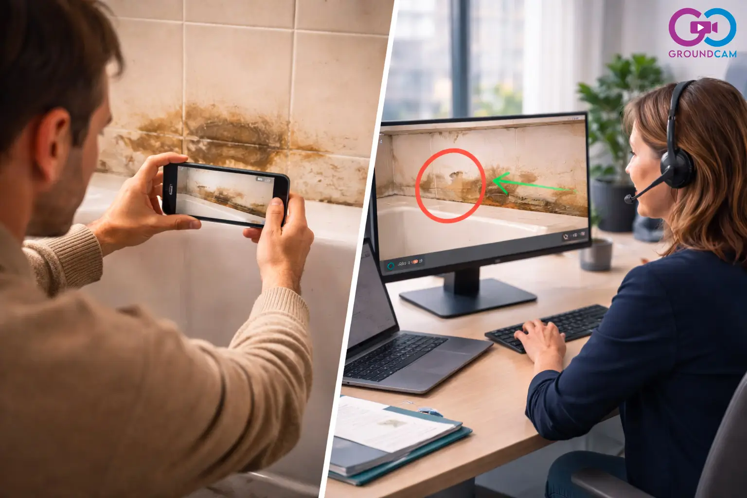
Remote Video Assessment
The insured shows damages live via their phone camera. The expert sees, questions, and documents without traveling.
Certified Evidence
Each capture is automatically enriched with GPS coordinates (<10m accuracy), UTC timestamp, and session ID. Non-falsifiable.
Compatible with your existing tools
Evidence is exportable and securely stored. Integrates with your claims management systems.
Real-World Example
A water damage claim is filed late in the day. The insurer launches a GroundCam session within the hour. In 10 minutes, the agent assesses the damage extent, captures the affected areas, confirms the location, and dispatches the right contractor. The client is handled faster and the case enters processing with objective evidence from day one.
Key sector indicators
| Indicator | Before video | With GroundCam | Gain |
|---|---|---|---|
| First-contact resolution (FCR) | ~70–75% | Improved (better diagnosis) | Fewer reopened cases |
| Expert travel | Many on-site assessments | Assessments & checks by video | Reduced travel |
| Claims processing time | Long | Accelerated processing | Faster compensation |
| Policyholder satisfaction (CSAT) | — | Rising | Better policyholder experience |
- Before video
- ~70–75%
- With GroundCam
- Improved (better diagnosis)
- Gain
- Fewer reopened cases
- Before video
- Many on-site assessments
- With GroundCam
- Assessments & checks by video
- Gain
- Reduced travel
- Before video
- Long
- With GroundCam
- Accelerated processing
- Gain
- Faster compensation
- Before video
- —
- With GroundCam
- Rising
- Gain
- Better policyholder experience
- FCR :
- First-contact resolution.
- CSAT :
- Customer satisfaction score.
Indicators observed in the visual assistance sector — results are indicative and vary by context.
Why visual assistance transforms insurance assessments
The insurance industry faces dual pressure: policyholders demand fast claims processing, while field assessment costs keep rising. An on-site assessment costs between €300 and €800, and the average delay between filing and inspection is 15 days. Remote visual assistance enables a first assessment within 24 hours of filing.
Evidence certification is a central concern for insurers. GroundCam automatically enriches each capture with GPS coordinates (3 to 10 meter accuracy), UTC timestamp, and a unique session identifier. These elements constitute traceable and tamper-proof digital evidence, usable in claims management and potential adversarial proceedings.
Beyond cost reduction, visual assistance improves fraud detection. Certified geolocation verifies that photos correspond to the declared claim location. Timestamps guarantee that assessments are made on the announced date. Insurers adopting this technology see a 40% reduction in expert travel and significant acceleration of the claims management cycle.
See GroundCam in action
Security & compliance
- Video captures that can support internal files, intervention reports or exchanges with insurers, subject to context, internal procedures and applicable legal requirements
- Remote assessment via SMS link, no account or app for the policyholder
- EU hosting, euro-zone restriction for payments
Frequently Asked Questions — Insurance & Assessments
- Are GroundCam proofs legally admissible?
- GroundCam captures constitute digital evidence enriched with GPS geolocation, UTC timestamp, and session identifier. They can be used in claims management and adversarial assessments. Their probative value is reinforced by the complete traceability of each session.
- Does the policyholder need to install an app?
- No. The policyholder receives an SMS link and connects in one click from their smartphone browser. No download required, no account to create. The connection works on all iOS and Android smartphones in under 15 seconds.
- What is the cost compared to a traditional assessment?
- A GroundCam session costs a fraction of the price of an on-site assessment (€300 to €800 on average). Video pre-diagnosis qualifies the claim remotely and only dispatches an expert when truly necessary, reducing assessment costs by an average of 40%.
Run a pilot on your next assessments
Free sign-up, first session included.